
Trip Log - The Petawawa River from Lake Travers to McManus Lake
2016 September 09-14
An account with photos of a five night canoe trip down the Petawawa River from Lake Travers to McManus Lake in Algonquin Park.
Almost exactly 40 years prior to this trip, Diana and Bob travelled from Wendigo to McManus via the Petawawa River. The present trip from Travers to McManus was duplicating the last section of the 1976 trip. It was a great trip, but in truth it did a good job of knocking the stuffing out of us. It was just about the limit of what this pair of old farts are currently capable of. But then that's a component of a great trip - pushing your limits but not quite exceeding them.
The first time down this section 40 years ago, we portaged everything. This time we tentatively planned to run Grillade, Schooner, Five Mile and the upper part of Crooked Chute (and miscellaneous small swifts), But it's been more than 25 years since we've run any sort of meaningful white water with a loaded canoe, so we were a little apprehensive - with good reason, it turns out. Because of the white water, we brought our expedition weight kevlar Kipawa out of retirement rather than risk our lighter weight Prospector.
In addition to commemorating our first trip down the Petawawa River, we also wanted to check out a couple of potential Tom Thomson painting locations at the Natch and to keep our eyes peeled for others along the way
We started at Lake Travers and finished at McManus Lake, camping at Lake Travers, Crooked Chute, The Natch, and Five Mile Rapids.
Our trip diary is reproduced below with only minor editing. Except for one entry, it was written by Bob. Material written after the trip, mainly by Diana, is enclosed in square brackets.
Friday September 09 - Lake Travers

(photo by Diana: 2016-09-09 - map - explore)
Getting ready to launch at the Lake Travers put-in.
11:13 drifting on Lake Travers having a snack:
We were away from house at 8:00, at permit office 9:00, at McManus at 9:40, at Travers at about 10:35, and launched at about 10:50. Two cars were in parking lot when we arrived at Travers but then several vehicles, 4 canoes, and 2 separate groups arrived as we were leaving. Slight breeze, sun is hot.
We reached our campsite at about noon – the same campsite we stayed at a few years previous [see Trip Report - Exploring Lake Travers.] There is someone camped at the next point south of us with a couple of guys out fishing in a motor boat (the same as when we were here previous). As far as we can see, the rest of the lake is empty. I guess I miscounted back at the parking lot since 3 groups have passed by – two single canoes and one group of three canoes. The group of 3 stopped for lunch at the moraine. One of the single canoes returned so I guess they were just out for a day trip.
The campsite is very nice and relatively clean. But when we arrived there were a couple of empty cans in the firepit and the fire was still warm – it had not been put out, just abandoned.

(photo by Bob: 2016-09-09 - map - explore)
The view down the lake towards the outflow of the Petawawa River from in front of our campsite on Lake Travers.

(photo by Bob: 2016-09-09 - map - explore)
Our campsite on Lake Travers.
We’ve had our snacks/lunch etc. and are now lazing the afternoon away – still too early for afternoon coffee.
15:50 and just finished afternoon coffee. Although the population on the lake is low, it’s all concentrated on three adjacent campsites. A family has just occupied the campsite adjacent to ours to the south. They’re noisier than we would like, but they’re not doing anything inappropriate or yahooish.
17:03 and the Black Bart Chili is hydrating. Measured boiling water for adding to FD dinner using the “fair share mug”. Diana claims it worked well. [All supper references are for Alpinaire freeze dried dinners.]
Chili was good; maybe a little runny.
19:00 – sitting on the beach (point) in front of our campsite with our Bushmills. Everything is squared away for the night. Wind calm, evening light on far shore, mackerelish clouds but not really malevolent looking. Noseeums are out but insect repellent is up in the tree with the food.
Into the tent at about 8:00 or thereabouts.
[Diana:
It was nice to get the campsite we wanted and have some time to set up and then relax in the shade. We poured some water on the still-warm remains of the fire to ensure it was fully out.
The family on the campsite next to us never seemed to stop talking, but on the whole they were well behaved. The two couples on the campsite beyond that had not been 'home' when we passed by, but returned from the north end of the lake later in the afternoon. By the contents of their canoes they had been poaching firewood from other campsites, and were about to visit ours when they noticed it was occupied.
Some loons on the lake.
Around suppertime, a couple went by in a red canoe. It looked like a whitewater boat and had an air bag. They camped on the shore facing the campsite on the moraine island.
Nice quiet night, slept well.]

(photo by Bob: 2016-09-09 - map - explore)
Sunset on Lake Travers.
Saturday September 10 - Lake Travers to Crooked Chute
7:05 and drinking our coffee under the tarp - although it hasn't been necessary - up at 6:20 - temp about 12C. Morning mist - couldn't see island opposite.
Good night - sleeping bags very comfy.

(photo by Diana: 2016-09-10 - map - explore)
Morning mist and the island opposite our campsite on Lake Travers.
On the water at 9:50 - not very impressive. Wind calm - starting to cloud over.

(photo by Diana: 2016-09-10 - map - explore)
Heading down Lake Travers towards Big Thompson Rapids at the end of the lake.
At Big Thomson at 11:00
12:00 - lunch stop at campsite at top of Little Thomson rapids. Canoe is through portage, everything else is here. I got confused portaging canoe and I got a tour of the thunder box.
Portage around Big Thomson is a real bugger, especially at the end [little did we know it would pale by comparison to the end of the Rollway portage.] There is an alternative put-in further upstream, but I rejected it because I didn't like the look of some rough water downstream. But it turns out you have to negotiate that regardless of which put-in you use.
Certainly we used to run Little Thomson but looking at it now I don't see a route through, at least at these water levels.

(photo by Diana: 2016-09-10 - map - explore)
Little Thompson Rapids. We used to run this; now we can't even identify a route through.
On the water again at 1:10.

(photo by Diana: 2016-09-10 - map - explore)
Canoeing selfie on the Petawawa River below Little Thompson Rapids.
It is now 17:00 and we are sitting under our tarp, eating our snacks and drinking our coffee, sitting in front of a warm but smoky fire. We're warm and dry but with soggy feet. The rain has stopped.
It started raining at about the last campsite of the Thomson set. It started to rain hard about halfway down Grillade and continued until we arrived here. 'Here' is the campsite at the second take-out on Crooked Chute. We haven't portaged since Little Thomson. That is, we ran the 'swift' above Grillade, Grillade, and the first part of Crooked Chute.
Our white water skills have maybe 30 years of rust but haven't disappeared completely. At these water levels the swift was the most difficult - we had a couple of touches - followed by Grillade. The first part of Crooked Chute was the easiest of the three. We probably could have safely continued to the third (and last) take-out, but we had planned on the second and that was the prudent action. The pouring rain didn't help either. We decided to stay because it would do.
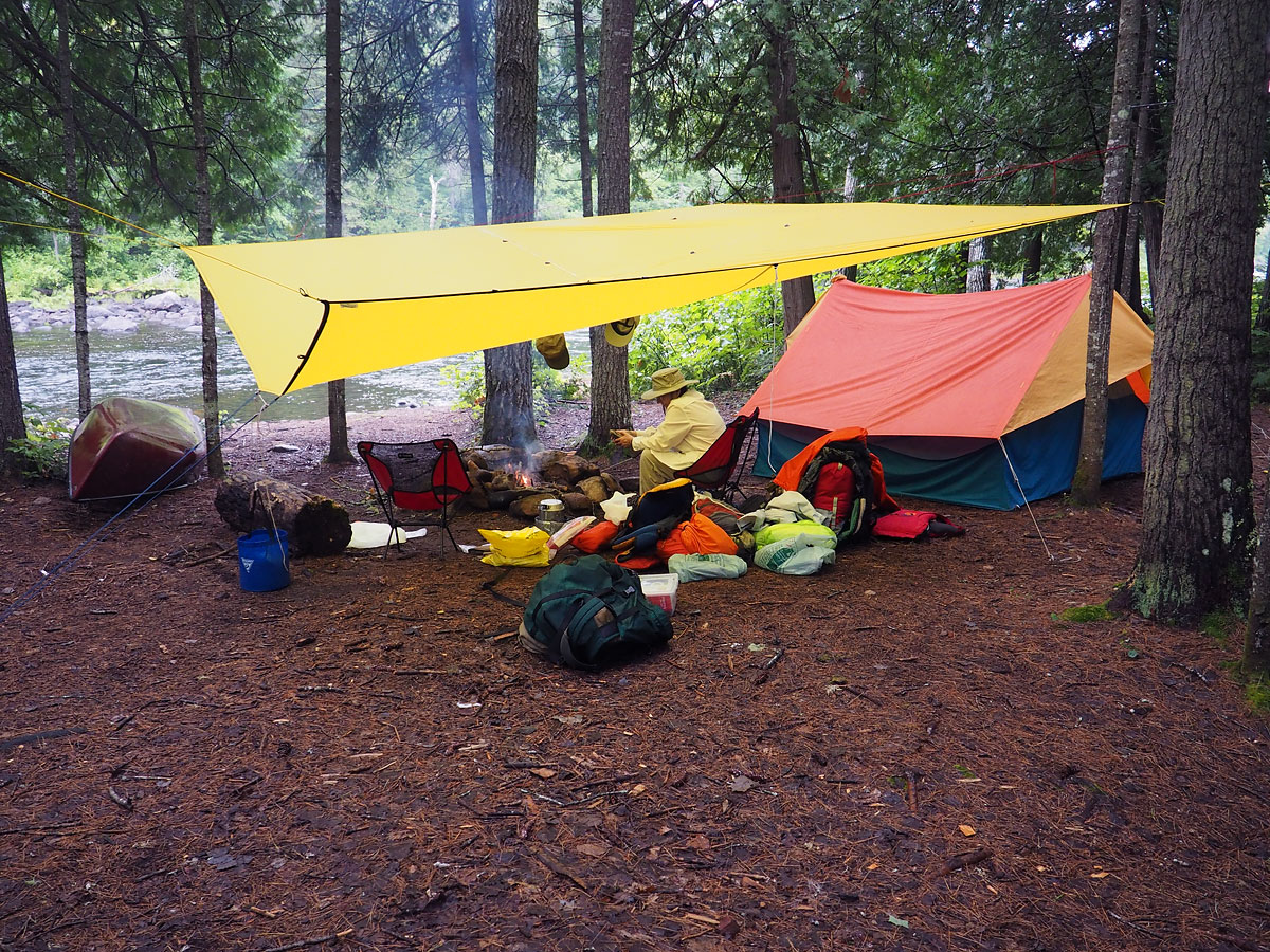
(photo by Bob: 2016-09-10 - map - explore)
Our campsite at the second take-out at Crooked Chute. In retrospect, this was an excellent choice of campsite.
Supper was Mesquite BBQ Seasoned Chicken with Beans and Rice. OK, we can have it again but not a favourite. A little sweet.
I thought hanging the food here was going to be a challenge, but I got a line over a maple tree leaning over the river, over 15 ft up.
8:00 - having our Bushmills.
.Just before supper it started raining hard again. Since we have everything under cover, it wasn't a major issue but a nuisance nonetheless. Then it stopped. The sun came out just before sundown, blue skies, etc. It has now clouded over again. Everything is under control except for a certain level of messiness under the tarp. The inside of the tent is still in disarray, but otherwise all is good - a good day.

(photo by Diana: 2016-09-10 - map - explore)
From our campsite at the second take-out at Crooked Chute. It had been pouring rain when we arrived here. This was the lull in the storm before a very violent night (trees cracking, branches falling onto the tent, etc.).
You can see our food rope hanging to the right of this photo (food, not yet hoisted).
[Diana:
The rain didn't seem too bad at first, but was a real torrent by the time we were running the approach to Crooked Chute. It was definitely the right thing to do to stop at the campsite at the second take-out. It is fairly level, roomy, and well sheltered by trees. Getting a fire going was a bonus - the warmth was very welcome, and it's always good for morale. (We don't usually bother with a fire any more.) The people in the red canoe (helmets on) passed us around suppertime, running down to (presumably) the third take-out. We did not see them again, nor any evidence of where they might have camped that night. We did not see any other people for the rest of the trip.
There were a couple of light showers during the night, then things cleared off. The moon was shining through the trees. Later on the wind came up and was quite strong and gusty, though we were sheltered from most of it (except for bits of branches coming down on the tent and tarp). I heard some ominous cracking of branches, but nothing close.]
Sunday September 11 - Crooked Chute to The Natch
7:10 - having our coffee. A wild night; wind blasting; very gusty; a little more rain; a few branch tips came down on the tent. A physically comfortable night, but not so much mentally with the wind and the noise - and the occasional shower of tree bits.
11C - low clouds booting it out of the north; pressure 1003 mB and rising.
11:15 - finishing up our snack break, drifting in the canoe below Crooked Chute.
We broke camp at 9:45 and finished the portage at 10:45. We made the right choice of campsite. The campsite at the last take-out is quite exposed and beaten to death, no comfortable looking tent spot.
Taking out at the second take-out was also the correct decision. There is no way we could have reached the last take-out, at these water levels and at our current skill levels [in spite of my previous comment.]
The portage was good but with one steep part near the end.

(photo by Bob: 2016-09-11 - map - explore)
The third (and last) take-out at Crooked Chute. Our tentative plan had been that we would camp here. But clearly we made the correct choice, camping at the second take-out. This campsite is very exposed and beaten to death.
[The next section was written by Diana at the foot of the Rollway portage:]
Drifted on the wide spot [below Crooked Chute] and had lunch #1. Looked at campsite and cabin [both unoccupied] from the shore. Cold wind. Under way about 11:20.
Ran swift (130m port.) Enter in the middle, follow water around to the right.
To Rollway portage about 11:55. 1st part of trail up then good walking. Got a bit rougher farther along. Decided not to launch at 1stput-in below ledge (no brainer). Carried on to near end - trail gets very rough. Broken rock and steep descent to water, but trail continues on a goat track high on the shore and eventually descends to decent launch spot marked by flagging tape on stick - [but by the time you can see the flagging tape, you can see the end.]
Relaunched about 1:15 and drifted for lunch #2.
Along the trail: Nice campsite near the beginning. Blair Fraser cross returned but [appeared to be] not remounted - just stuck between rocks. 'Nudist beach' from 1979 now all overgrown with alders, etc. (When we passed by here on a trip in 1979, this was the campsite of a group of nudists.)
Took some photos of [Rollway] rapids. Blue frame pack on a rock out in the water just above ledge (???.) [Would like to know the story behind this.]
Diana had considerable difficulties at the end of this trail, but Bob helped her out (as always.)
Cool and windy, but sunny with blue sky and white puffies.
Bob has pumped some water. It is now 1:43.

(photo by Diana: 2016-09-11 - map - explore)
Memorial to Blair Fraser at Rollway Rapids. The memorial was vandalized in 2008; the stub of the original bottom part of the cross can be seen in the background. The cross was found in the river during the drought year of 2012, and has been remounted. Although it appears to have just been stuck between some rocks, it is actually solidly cemented in place, with rocks placed around it for a more natural appearance. The story of Blair Fraser and the remounting of the memorial can be read here: Borne back into the past: Three generations paddle down the Petawawa in memory of Blair Fraser.

(photo by Diana: 2016-09-11 - map - explore)
The ledge in Rollway Rapids. We used to launch here and run the lower portion of the rapids but not at these water levels and not with our current skill levels.

(photo by Diana: 2016-09-11 - map - explore)
Negotiating the end of the portage at Rollway. Bob is not tired so much as he is concentrating very hard.
[back to Bob:]
17:20 sitting under the tarp at the Natch - el primo campsite - waiting for coffee to cool. We arrived here at about 4:00 and are essentially all set up.
We had naively hoped that one or both of the portages at the Natch rapids could be sneaked or bypassed - such was not the case. With respect to the first portage, George Drought says 'You have to be a mountain goat to do this portage'. He's right, but it's not as bad as I remember it from 40 years ago.

(photo by Diana: 2016-09-11 - map - explore)
The mountain goat trail around the first part of Natch Rapids. If you look carefully in the centre of the upper right quadrant of the photo, between the trees in the distance you can just make out a wooden bridge that crosses a little ravine on a lower part of the trail.

(photo by Diana: 2016-09-11 - map - explore)
Launching canoe at the end of the mountain goat trail.
We had no memory of the second part of the Natch rapids - either the rapids or the portage. The rapids were not runnable by us, thus the portage. Diana was feeling a bit rough - she took through 1 load while I took through 3. This slowed us down somewhat.
The day remains cool - 15C - sunny but partly cloudy. The wind has largely abated.
Supper was Brown Rice with Chicken and Vegetables. Not very exciting but OK. Perhaps a welcome break from the over spiced BBQ flavours.
20:15 - all squared away. About to have our Bushmills. Night is calm, cool (11C). 5/8 moon is illuminating the campsite.
A hard day but it's behind us.

(photo by Bob: 2016-09-11 - map - explore)
The Natch.

(photo by Bob: 2016-09-11 - map - explore)
Campsite at The Natch.

(photo by Bob: 2016-09-11 - map - explore)
As the sun sets, the shadow moves up the face of The Natch. While much of the Natch is still sunlit, the opposite shore is in shadow.

(photo by Diana: 2016-09-11 - map - explore)
Eventually, the entire cliff face is in shadow.
[Diana:
It was nice of Bob to say only that I was "feeling a bit rough" on the second Natch portage. I hadn't been able to cross the bridge at the end of the Rollway portage without his assistance (I have no head for heights). Then I nearly died on the first Natch portage - Bob had to give me some assistance near the end of that one too. I don't know how he managed to carry the canoe up and down all those steep bits. The second Natch portage doesn't climb up and down as much, but it's just as rough. I bonked after taking one big pack through and had to sit down, feeling sick. Bob brought everything else through. And there's a narrow spot between big rocks that looked nearly impossible to fit the canoe through, but somehow he did it. Finally, when we were relaunching I slipped and landed on my butt (ow!) on some rocks, and got a bit wet. And Bob's PFD decided to go for a swim - fortunately there was not much current there and I was able to get moving quickly enough and into the canoe that we caught the PFD before it escaped completely. Not my best day.
I don't know how we ever used to get around any of that or run any of those rapids in the old days. Thank goodness it was a short, calm paddle down to the Natch proper, and very nice to find no one there and the number one campsite available. We were pleased to be able to set up camp and just admire the scenery for a while. We did take an awful lot of photos there.]
Monday September 12 - The Natch
6:55 - waiting for the coffee water to boil. Calm, still morning, sky looks clear, 8C, 1016 mB. Sun not yet clear of the Natch but silhouetting it. Some morning mist at the top and at the water surface moving downstream.
8:30 - sun just clearing the top of the cliff - 10C.

(photo by Bob: 2016-09-12 - map - explore)
The Natch at sunup.
9:45 and about to embark on climbing to the top of the cliff.
11:11 - relaxing at the top of The Natch. The climb took about an hour. The climb - scramble - is quite difficult in places - especially going around the end of the 'little bay' - but here at the top it is just a pleasant walk in the woods. However, down at the end of the bay it is reminiscent of the route from High Falls Lake to High Falls Pond - that is, various paths going off in all directions, looking for the easy route. But in reality, there isn't one.

(photo by Bob: 2016-09-12 - map - explore)
Diana at the top of The Natch. She has a firm grip on the tree as she is not comfortable with heights.

(photo by Bob: 2016-09-12 - map - explore)
Looking upstream on the Petawawa River from the top of The Natch. Our canoe at our campsite should be just discernible on the right hand shore.
Back in camp at 12:05. On the way up there was a somewhat scary overhang you had to work around, with a significant rocky drop off the right. I had to take my pack off so I wouldn't be overbalanced. We weren't looking forward to it on the return leg. But we didn't encounter it; so clearly we took a slightly different route coming back than going up.

(photo by Bob: 2016-09-12 - map - explore)
Black spruce across from our campsite.
15:15 just returned from matching up locations with TT [Tom Thomson] paintings and photos we have taken previously. We are now reasonably convinced that the TT painting Petawawa Gorges (shadow) [proper name: Petawawa, Algonquin Park] was indeed painted at the Natch.

In addition to marking the 40th anniversary of our first trip down the Petawawa, a secondary motivation was to determine whether the Tom Thompson sketch Petawawa, Algonquin Park (shown here) was painted at the Natch or in the Barron Canyon. Reasonable matches to the sketch can be found in both locations. We are now convinced that it was painted here; the behaviour of the shadow on the cliff face was an important aspect of this conclusion. However, getting a good photographic match to the painting is difficult due to the regrowth of the forest in the last 100 years.
A complicating factor with the shadow painting, [ Petawawa, Algonquin Park ], is that the sand bar in the river is now heavily vegetated and obscures the view. We suspect that the painting location was probably on that sand bar [and that the sand bar was free of vegetation to facilitate log driving].
We couldn't get a match for the sunset picture [proper name: Petawawa Gorges, Night], but maybe. [There is a possible match in the Barron Canyon, but it is also not quite convincing. (And of course, if it is of The Natch, we will have to start referring to it as the 'sunrise picture'.)]
Upon return we had 'Cup-A-Soup' double strength - or rather, design strength for our large mugs. Followed by coffee.

(photo by Bob: 2016-09-12 - map - explore)
Relaxing at the Natch.
It is now 17:45 and I have just put on the supper water. To do so, I had to start on fuel bottle #2.
Supper was Pepper Beef with Rice - bland but OK.

(photo by Diana: 2016-09-12 - map - explore)
Dusk
19:16 - 12 min to sundown - Diana is pouring the Bushmills. First bottle (about 350 ml) is finished.
[Diana:
Lovely day at the Natch. Took loads of photos from all angles in all sorts of lighting. The climb to the cliff top was a good workout (never skip leg day - or as Bob said, 'this is leg day'.) Anyway, the view was great and well worth the climb. It was sunny and windy and very nice at the top; we relaxed and had lunch #1. Some evidence of deer or moose on the path at the top. It was a surprise how much less time it took us to get down than to climb up. Note: the spring is actually very close to the campsite - the rough part of the trail starts after you cross the stream.
Spent part of the afternoon out in the canoe paddling around trying to match the landscape with TT paintings. Fun thrashing through the bushes on the sand bar. Possibly some results.
Returned to camp and relaxed. Some of the vegetation suggests long time human occupancy there - perhaps a logging era cabin. There is grass, clover, plantain and dandelions, among other things.
Birds: lots of noisy blue jays, distant ravens, chickadees, juncos foraging around the firepit. I heard a robin but did not see it. Also heard raccoons cracking clams on the rocks by the shore just before sunrise.]
Tuesday September 13 - The Natch to Five Mile Rapids (Whitson Lake)
6:50 - sitting, drinking our Italian Roast Via, and watch the mist rise from the river and the Natch. Temp 10C, pressure about steady at 1011 mB.

(photo by Diana: 2016-09-13 - map - explore)
The Natch at sunup.

The location of this Tom Thomson sketch, Petawawa Gorges, Night, was of interest but not a major focus of our stay at The Natch. The issue is that you can sort of match it in the Barron Canyon, but not that convincingly. It seems that the same is true at The Natch. The problem in both instances is the relative size and shape of cliff on the right had side of the painting. To match this painting at The Natch, you would need to be a little farther to the left of the previous photo.
On the water and away at 9:30.
12:05 - just finishing lunch (no morning snack) [on shore] at the power lines, sitting in the sun drying off.
We had a mishap near the top of Schooner. Got crossways to the current on some rocks. Had to disembark mid river. We got the canoe leaning downstream just in time to prevent the upstream gunwale going under. Otherwise we would [probably] have lost the canoe. As it was, we took on some water (over the upstream gunwale) but not a disastrous amount. Once we were out of the boat, I was able to lift one end clear of the rock [at the stern end] and thus free the boat. We waded the boat to shore, but some of the holes [in the river bottom] were chest deep. On shore, we removed the packs, emptied the bilge water and were able to re-embark. Since we were on the side of the river away from the portage we had little choice but to relaunch. Once we got under way, our confidence returned and we ran the rest of the rapids without incident other than a few minor scratches. By the end we were starting to get our [some of our] reflexes back.

(photo by Diana: 2016-09-13 - map - explore)
The bridge across the Petawawa River at the power lines.
Back in the 1980s, when we used to run this river with other white water enthusiasts from Deep River - often led by Don Smith (who later formed Valley Ventures offering whitewater trips on the Petawawa and DuMoine), we might camp on Lake Travers on Friday night, here on Saturday night if we couldn't get the large site at The Natch, and get to the take-out at McManus by noon or a little later on Sunday (at June flow levels). There was a large camping area between the river and the road that could accommodate large groups. It was never a good camping spot but it was large and convenient. That camping area is now completely overgrown with alders. There still remains a small camping spot on the far side of the road behind the alders. It is not signed nor is there a proper fire pit. And of course no thunder box (and the old outhouse is gone). Our take is that even though this site still appears on the "ranger approved" park map, the site is no longer considered an official campsite and one would only camp here in desperation.
With respect to the old outhouse. I remember one June trip where as part of a large group we arrived here late in the day. That year a ground hog had concealed the entrance to his burrow in the pit under the outhouse. As soon as we landed, a long line up to the outhouse formed (no one had been out of their boat since at least The Natch). That was one pissed off ground hog.

(photo by Diana: 2016-09-13 - map - explore)
Canoeing selfie on Coveo Lake.

(photo by Diana: 2016-09-13 - map - explore)
Storm damage on Coveo Lake. It seems to be too fresh to be from the storms of 2006 or 2011, so we assume that perhaps it is due to the storm from late last fall.
15:20 - sitting under the tarp at the small campsite on the northeast side of the river at the foot of Five Mile Rapids.
We arrived here a little after 14:00, thus about an hour from the power lines.
No major issues in Five Mile or the bottom of Schooner, but a few touches. We had to step out of the canoe twice in Five Mile due to shoaling out.
Things were working better in this run as I just let Diana choose the route - even when I didn't agree with her choice - and then just tried to ensure that the stern took the same route through as the bow.
It has completely clouded over, first with high cirrus and now lower with cumulus (with a touch of nimbus). Barometer is 1010 mB, the same as this morning. Temp 24.
I think both of us are feeling more beat this evening than any previous day. The mental stress is harder on us than the physical stress.
Most of our stuff came through dry. Some of the bags were a little wet on the outside but nothing critical got wet. Except for our permit. Totally sodden. And the pen used to record our itinerary was clearly not waterproof. The permit is washed completely clean. Which is a shame, since it is one of our few recent trips where we have been exactly on permit every night - although we will return home tomorrow rather than Thursday. [We had scheduled an extra day in the event that we ended up carrying around everything.]

(photo by Diana: 2016-09-13 - map - explore)
Bob at our campsite at the bottom of Five Mile Rapids, waiting for the coffee water to boil, Diana's clothes drying on the line.
We found it interesting to identify the pieces of equipment in this photo that also made the original trip with us 40 years ago: tent and fly, orange food bags, cooking pot, and white plastic water bottles.
17:00 and it has just started to rain lightly but steadily. But we're securely under our tarp.
Shower stopped at 17:20. Supper was Sierra Chicken Pasta - mixed reviews. Bob more positive than Diana. Diana thought, "OK but meh"! Bob thought, "warm tomato pasta glop". Temp now 19C. Pressure still 1010 mB.
19:20 - Bushmills time - an osprey came to visit earlier. A couple of light sprinkles of rain but nothing serious. Still warm at 20C.
[Diana:
Not sure what happened in Schooner - perhaps a combination of a failure to communicate and some misreading (or slow reading) of the rapids. Anyway, we survived, and the only thing I had that got soaked was some kleenex in my pants pocket. Thank goodness for Ziploc bags - even my camera stayed perfectly dry in spite of my being in water up to my armpits. (The camera, in its Ziploc, was in an non-waterproof camera bag slung over my shoulder.)
We looked for the campsite at the hydro lines - the one we stayed at with Don Smith - and it has been completely overgrown with alders. There is a landing and a bit of a trail up to the road, then an open grassy spot that obviously is camped on, but not much of a campsite.
Enjoyed the sun and dried off a bit.
The rest of Schooner and all of Five Mile went pretty well. Coveo Lake still has the very noticeable browse line on the cedars that Bob recalled from years ago. There is also a swath of wind damage - perhaps from the storms that came through here last fall. The new growth is too short for it to have been much longer ago than that.
Got our camp set up and put everything out to dry. Hung clothes on one of the tarp guy ropes and put on a complete dry set of clothes - felt very good.
Fun to see the osprey up so close, though couldn't get any good photos. A family of Canada Geese were practicing flying in a group, presumably getting in shape for migration.]
Wednesday September 14 - Five Mile Rapids to McManus Lake
Morning coffee at 7:15. Sky overcast, wind light to non-existent, pressure 1016 mB, temp 13.

(photo by Bob: 2016-09-14 - map - explore)
Diana enjoying her morning coffee at our campsite at Five Mile Rapids.
Diana's green down jacket also made the trip 40 years ago. (As did her painted paddle, but it doesn't appear prominently in any of the photos presented here.)

(photo by Bob: 2016-09-14 - map - explore)
View from our campsite on Five Mile Rapids. Actually, I (Bob) think that I just took this picture to assure myself that my camera still worked. It too survived total immersion in Schooner Rapids, protected only by my belt pouch and a Ziploc bag.
Away slightly after 10:00, heavy overcast, chill wind out of the northwest. A couple of very light sprinkles as we were packing up. Dull day, not very picturesque.
11:20 just finishing our snack break about 1/3 of the way down Smith L.


(photo by Diana: 2016-09-14 - map - explore)
We were pleased that the army chose to honour us with a two gun salute to acknowledge the end of our trip. But the guns weren't in position as we paddled down McManus Lake so they had to hustle. They managed to get a few rounds off before we reached the take-out.
12:45 McManus Lake put-in.

(photo by Diana: 2016-09-14 - map - explore)
Disembarking from the canoe at McManus Lake. The old ankles can't cope with the constant kneeling anymore but Bob just doesn't feel comfortable sitting.
13:10 off to Lake Travers
14:00 Lake Travers parking lot
15:00 back at McManus Lake
Home at about 16:30
Overall an excellent trip, just about at our limits for a couple of seniors, but within those limits. It was great having the Natch to ourselves for 2 nights in excellent weather.
The Kipawa was the correct choice; I think the Prospector would have been too fragile. But I certainly noticed the extra 20 lbs. Any heavier and I wouldn't be able to get it up - I need some canoe Viagra. However, thinking about my younger days with the Grumman and the St. Maurice, I rarely flipped those canoes up; I used to cheat and roll them up from the bow (or stern) and then back into position for carrying.
[Diana. The Kipawa weighs about the same as our old Grumman (15' lightweight) but is very different to paddle, especially in rapids. The Grumman was flat-bottomed with a prominent fin keel, which gave a really good bite for ferrying. It was also quite wide and bosomy, which made it ride over standing waves well and allowed a wide stance for kneeling in the bow. I found the narrower kneeling space in the bow of the Kipawa meant that I wasn't as well braced. The Kipawa is keel-less and tilts more easily, so doesn't feel as stable (at least initially) as the Grumman. I don't know if the asymmetry of the Kipawa makes a big difference in rapids or not.
While we were stopped at a campsite on Smith Lake, a couple of Chinooks from Petawawa appeared farther down the lake and then turned and left before I could get a photo. Near the top of McManus, we heard them again, so got ready with the camera. Soon one came over the treetops, with an artillery piece slung underneath. Got a good photo, then another helicopter with another artillery piece appeared as well. Cool! Before we got to the take-out at the bottom of the lake, we heard firing from the nearby range - presumably they set the guns down, got them set up, and fired a few rounds. Nice to have a 'two gun salute' to mark the end of a good trip.
'Ear worms' - those bits of music that obsessively run around in your head and just won't go away. And they're particularly noticeable on canoe trips when there isn't a lot of other noise to distract you. Years ago I always used to have to put up with the Muppets' theme song on portages; later on it faded and other songs took its place. This trip I had three songs taking turns: 'Bargain Shop Panties' by Little Miss Higgins; 'What a Shame' by the Rolling Stones; and 'You Shook Me Baby' by the Black Crowes with Jimmy Page. A nice bluesy selection, and fortunately I still seem to be able to enjoy listening to them.]
[Bob: While I agree with Diana's comparison of the Grumman with the Kipawa, the fin keel on the Grumman added unnecessary extra depth and the aluminum was grabbier than gel coat when lightly kissing a rock in passing.]
For more photos from this trip, see our associated photo gallery: Petawawa River - Lake Travers to McManus Lake and also Petawawa River Canoe Trip — Then and Now.
Disclaimer: This account is solely a record of what we did and is not a recommendation to others. A case could be made that some of the actions described here were not appropriately prudent. You alone are solely responsible for your own route selection and safe conduct.