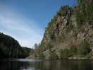
The Barron Canyon
The Barron River Canyon is a Nature Reserve Zone in Algonquin Park. According to the Natural Heritage Information Centre:
The Barron River Canyon consists of a series of spectacular gorges with granite walls towering 100m and more above steep talus slopes which grade down to the water. Geological activity along the faulting zone has concentrated calcareous material along crevices and seepage areas, encouraging the growth of calcicolous plant species otherwise rare in the Site District and Algonquin Provincial Park. A number of these are relics of post glacial times that are otherwise rare in southern Ontario. The passage of a major post glacial drainage system through the Canyon is likely responsible for the introduction of a number of such taxa. The rocky shores and shallows of the Barron River support a number of locally and regionally rare southern taxa. Backshore forests are primarily intolerant mixed and coniferous vegetation dominated by Red Pine, White Pine, Trembling Aspen, White Birch and White Spruce, with scattered groves of Eastern Hemlock and Eastern Cedar on steep, cool slopes. The boggy ponds (such as Ooze Lake) and creeks in the zone frequently exhibit emergent, peaty shores in late summer.
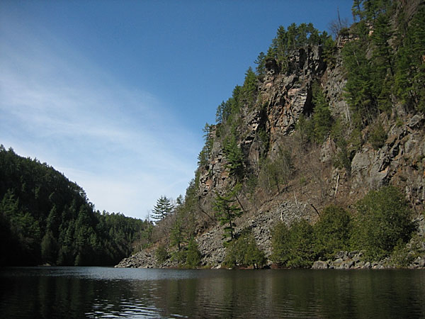
Near the upstream end of the Barron Canyon looking upstream. The most spectacular cliffs of the Barron Canyon are along the north rim (to the right in this photo). However, the highest local elevations actually occur south of the canyon. This photo shows the talus buildup at the foot of these cliffs. However, at other locations, the cliffs drop straight down into the river without any talus buildup.
The Barron Canyon is the manifestation of a fault that runs along the Barron River; it is a secondary fault associated with the Ottawa Bonnechere Graben, running roughly parallel to the long axis of the graben.
The Ottawa Valley is a rift valley, a dropped down block of bedrock several tens of km wide, known as the Ottawa Bonnechere graben. It is associated with the breakup of the ancient continent Rodina.
The graben is significant with respect to several aspects of the Barron Canyon:
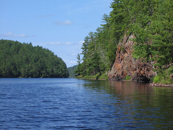
The lower Barron Canyon runs for a 4km stretch downstream of First Chute, outside of Algonquin Park. Here the river is wider and the canyon walls lower. The orientation of the fault here is slightly transverse to the axis of the graben. It is believed that the Champlain Sea reached upstream into this canyon.
The Barron Canyon lies along a secondary fault associated with the graben.
The bedrock faulted along the axis of the graben and that resulted in a line of broken, shattered and weakened rocks that was eroded or cleaned out by subsequent events. Certainly the drainage of glacial Lake Algonquin would have played an important role, but whether or not that is the complete story is not clear; there many millions of years previous for other processes to be active.
(photo by Bob: 2006-04-27 - explore)
The Barron Canyon in Algonquin Park is along a fault associated with the Ottawa Bonnechere Graben. Here the orientation of the fault is roughly parallel to the long axis of the graben.
The graben provided a drainage path for glacial Lake Algonquin.
At first the outflow of glacial Lake Algonquin was through the Fossmill Outlet down the Petawawa River valley; later the outflow was down the Ottawa Valley. When the glacial flow was down the Petawawa River some of that flow passed through the Barron Canyon.
(photo by Bob: 2005-07-15 - map - explore)
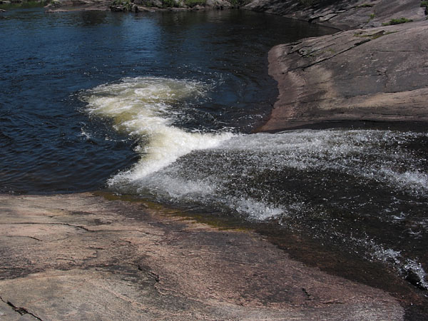
The natural water slide at High Falls on the Barron River, near Achray, in Algonquin Park. Here, the modern Barron River begins its fall into the canyon, which is several kilometers farther downstream. This is a glacial spillway. However, even a flow of a "thousand Niagaras" was limited in how much it could polish hard, largely insoluble gneiss.
Many accounts of the Barron Canyon, comment that it has been estimated that during the Fossmill drainage, the flow of the Barron River was equivalent to a thousand Niagaras. Certainly such a statement makes good copy, but what does it mean? What do we mean when we talk of the Barron River during the Fossmill drainage — the flow through the canyon, or the flow of the total drainage? Only a fraction of the water that passed over the controlling sill at the end of Mink Lake passed through the canyon and yet it was all one vast river.
To understand the full extent of the Fossmill drainage, you need to look where the sand plains are.
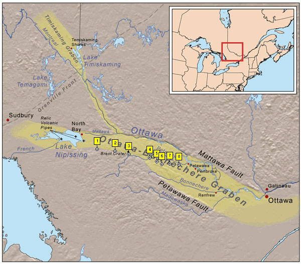
The Ottawa Bonnechere Graben. (Base map courtesy of Wikipedia — see notes)
1. Fossmill: As the glacial ice sheet retreated north of Fossmill (the ice front was approximately east-west at that time) the Ottawa Bonnechere Graben provided a drainage path to the Champlain Sea (which reached up the Ottawa Valley to Petawawa and beyond) for glacial Lake Algonquin.
2. The sill at the eastern end of Mink Lake controlled the flow into the Petawawa River drainage.
3. Cedar Lake; 4. Lake Travers; 5. Clemow Lake; 6. Grand Lake; 7. Barron Canyon; 8. Lower Barron Canyon.
The Fossmill drainage channel followed the chain of lakes from Lake Kioshkokwi to Cedar Lake and then down the course of the Petawawa River. Somewhat upstream of Lake Travers, it began to spread out and drop sand, bounded to the north by the Petawawa Hills. That is, the northern edge of the drainage was roughly where the modern Petawawa River flows. The southern edge of the flow was approximately the line defined by the hills along the south-western shores of Clemow Lake, Grand Lake, and into the Indian River valley. (This is not quite accurate because there was also some flow to the south-west of Grand Lake that joined the main flow via Carcajou Bay. Indeed, I suspect that there may also have been some leakage into the Bonnechere River Valley.)
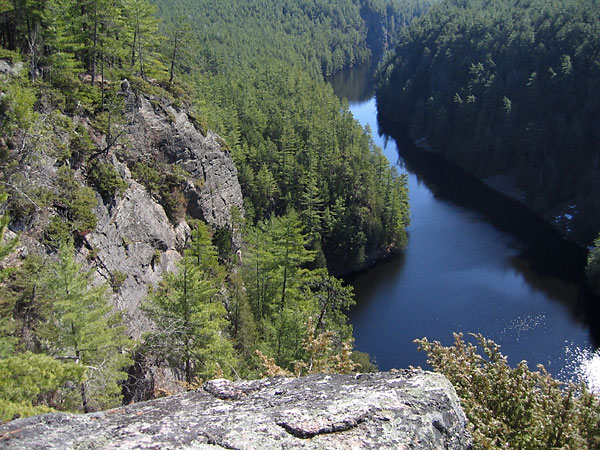
The modern observation points on the Barron Canyon Trail were isolated on an island in the middle of this vast river. One channel of that river flowed through the Barron Canyon. Much of the total flow was elsewhere.
Faults associated with the graben retained limestone through the ice ages.
The fault associated with the Barron Canyon was probably formed during the breakup of the supercontinent Rodina some 570 million years ago and reactivated during the breakup of Pangea some 150 million years ago. Further, this whole area was episodically submerged beneath shallow seas and coated with limestone. The limestone intruded into the many cracks and fissures of the Barron Canyon fault. Most of the surface limestone was removed by subsequent glaciations. However, traces of limestone remain in the canyon because it was less exposed to the glaciation (or so the story goes).
(photo by Bob: 2005-05-18 - explore)
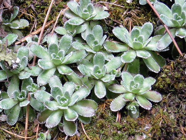
Encrusted Saxifrage or White Mountain Saxifrage (Saxifraga paniculata) is a locally rare plant found in the Barron Canyon in Algonquin Park. It is an arctic plant that requires lime. The little white spots on the leaf margins of this plant are actually small spicules of calcium carbonate (lime).
According to the Barron Canyon Trail Guide, the nearest neighbouring community of encrusted saxifrage is on the north shore of Lake Superior. (But I'd like to check out the north facing cliffs of Eustache Lake.) Their presence in Barron Canyon is a relic of the ice age. They have survived in the cool depths of the canyon for several thousand years.
I suggest that there is another mechanism contributing to the lime content of the water on the canyon walls. The bedrock is microscopically fractured, and groundwater slowly diffuses through it. The water that reaches the surface of the canyon walls is very old. The older the water is, the longer it has had to dissolve trace amounts of limestone throughout the bedrock. Thus the lime content of the water emerging from the cliff faces is also a consequence of the age of the ground water rather than being solely due to high limestone concentrations local to the canyon.
Whatever the complete explanation, the reality is that many lime loving plants may be found in the canyon.
(photo by Bob: 2007-10-22 - explore)
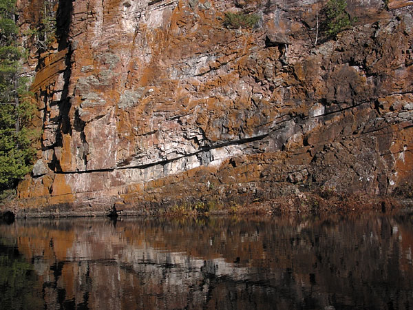
A cliff face in the Barron Canyon in Algonquin Park. Xanthoria lichens contributes to the orange colouring of the cliff faces. Xanthoria is a limeophile (lime lover — sounds like an insult from a rude robot in a Future Shop commercial!)
Eastern white cedar, another limeophile, is relatively common along the Barron River.
Notes
The map of the graben is courtesy of Wikipedia and is published under the following license:
This file is licensed under the Creative Commons Attribution ShareAlike 2.5 License. In short: you are free to share and make derivative works of the file under the conditions that you appropriately attribute it, and that you distribute it only under a license identical to this one. Official license
The map included with this page is subject to the same conditions of use.
Sources
Early Spring in the Barron Canyon
Natural Heritage Information Centre Natural Areas Report: BARRON RIVER CANYON
Natural Heritage Information Centre Natural Areas Report: RACEHORSE RAPIDS CANYON (lower Barron Canyon).
L.J. Chapman and D.F. Putman (1973); The Physiography of Southern Ontario, Second Edition, University of Toronto Press.
Nick Eyles (2002); Ontario Rocks, Fitzhenry & Whiteside.
Friends of Algonquin Park (undated); Barron Canyon Trail Guide.
J.E. Harrison (1972), Quarternary Geology of the North Bay — Mattawa Region, Geological Survey of Canada, paper 71-26.