
The Ottawa Bonnechere Graben

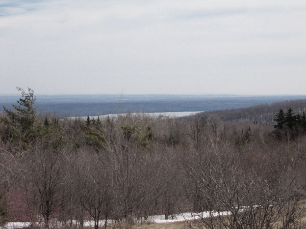
View along the Deep River Reach from the top of Oiseau Rock looking upstream (north-west). Chalk River Laboratories is just visible behind the trees on the left (south shore). Continuing up the south shore, next is McQuestions Point. The sand on the south shore farther upstream is in the vicinity of Point Alexander (about 19 km upstream). (The town of Deep River is hidden in this view.) The river undergoes a very minor bend to the left in the vicinity of Presqu'isle (out of sight behind the headland on the right), which prevents a clear sight line, even from the center of the river, all the way to Swisha.
Along the Deep River Reach, the Ottawa River flows along the fault that marks the northern edge of the Ottawa Bonnechere graben. The Ontario shore is dropped down relative to the Quebec shore. The river reaches depths of 75 m along this section of the river.
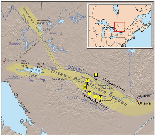
The Ottawa Bonnechere Graben. (Base map courtesy of Wikipedia — see notes)
1. Oiseau Rock; 2. Egg Rock; 3. Shrine Hill, Wilno; 4. Foymount; 5. Clontarf; 6. Barron Canyon.
According to L.J. Chapman and D.F. Putman (1973):
... the Ottawa Valley is the only major fault or dislocation due to the breaking of bedrock in southern Ontario.
The Ottawa basin is bounded on the west by the Frontenac Axis, an arch in the rock between Algonquin Park and the Adirondacks. This is visibly expressed in the Thousand Islands, where the Precambrian rocks appear on the surface, the overlying limestones appearing to the east and west. Many of the thousand islands are granite knobs. The Ottawa basin is sharply bounded on the north, just beyond the Ottawa River by the edge of the shield that rises abruptly to a height of about 300 m. This is the result of faulting, the block to the south having dropped down so as to place the overlying sedimentary rocks in a protected position where they escaped the full forces of erosion. The dropped down block is bounded on the west and south by faults and is tilted towards the west.
West of Ottawa the main fault passes through the hamlet of Hazeldean and forms the northern flank of the Carp Valley.
In Renfrew County there are prominent scarps on both sides of the Ottawa Valley, the southwestern one lying south of Calabogie Lake, Mt. St. Patrick and Clear Lake. Thus a block 35 miles in width is down-dropped, forming what has been called the Ottawa Bonnechere graben. Within it are several minor breaks. These are three south facing escarpments bounding blocks that are tilted towards the north, and in each case Palaeozoic limestones are preserved on their northern flanks. These are the Muskrat scarp along the northeast side of Muskrat Lake, the Dore scarp extending from Lake Dore past Renfrew towards Arnprior, and the series that can be seen intermittently along the north side of the Bonnechere River upstream from Northcote Station, and northeast of Golden and Round Lakes.

Looking up the Bonnechere River Valley from Egg Rock on the boundary of Algonquin Park. The western edge of the Ottawa Bonnechere graben is visible on the skyline to the left. The eastern edge of the Bonnechere River Valley (immediate foreground and visible on the skyline to the right) corresponds to a fault associated with the graben but does not constitute a boundary of the graben.

(photo by Bob: 2006-08-13 - explore)
The View from Shrine Hill, Wilno, with Round Lake in the far distance. Shrine Hill is on the western edge of the graben.
Looking east across Lake Clear and the graben from Foymount.

Looking north over Golden Lake from the Opeongo Road just below Foymount.
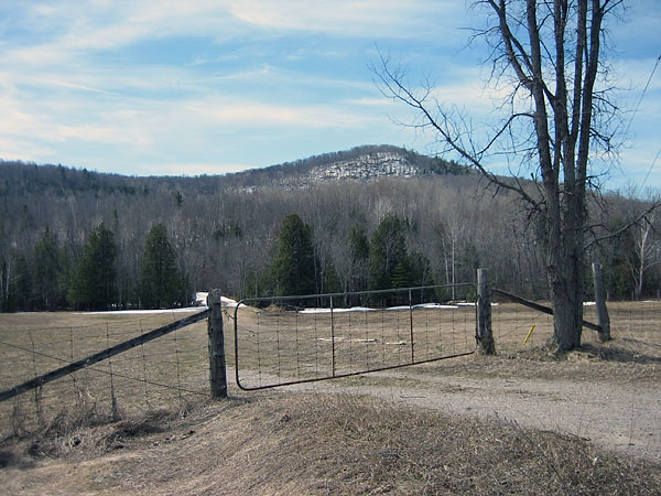
The Opeongo Mountains constitute the western edge of the graben. This view of them is from the Opeongo Road near Clontarf.
According to Nick Eyles (2002):
The graben was formed hundreds of millions of years ago and is associated with the breakup of an ancient continent. When the lithosphere fractures during continental breakup a three armed rift called a triple-junction is created. Two arms widen and eventually form a young ocean with a spreading center along its floor. The third arm ceases to develop further and is called a failed arm or aulacogen.
... in southern Ontario and Quebec aulacogens probably formed during the breakup of the supercontinent Rodina some 570 million years ago to form the Ottawa-Bonnechere graben and the St. Lawrence Rift. These structures were reactivated during the breakup of Pangea some 150 million years ago. Lakes Nipissing and Temiskaming and the Ottawa River follow the Ottawa-Bonnechere graben.
The splitting of Rodina gave rise to the opening of the Iapetus Ocean.
(photo by Bob: 2006-04-27 - explore)
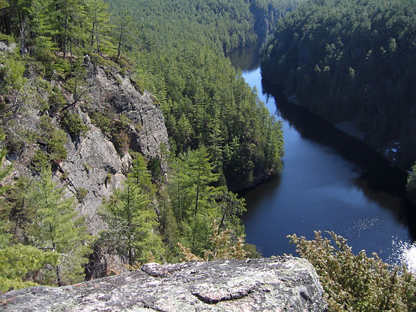
Barron Canyon in Algonquin Park is along a fault associated with the Ottawa Bonnechere graben.
The Friends of Algonquin Park (1994) state that:
... about 500 million years ago, after the Grenville Province Mountain chain had been eroded away and its crystalline roots exposed, this region was submerged beneath a shallow sea and marine sediments, mainly limestone, were deposited on its surface. Some time later, the region was uplifted and at the same time broken into large, northwest-trending blocks bounded by faults. The Barron Canyon is one such fault; the canyon formed originally along the line of weakness made by the fault and has been enlarged to its present gaping proportions by erosion of the rocks on either side of the fault itself.
Notes
The map of the graben is courtesy of Wikipedia and is published under the following license:
This file is licensed under the Creative Commons Attribution ShareAlike 2.5 License. In short: you are free to share and make derivative works of the file under the conditions that you appropriately attribute it, and that you distribute it only under a license identical to this one. Official license
The map included with this page is subject to the same conditions of use.
Sources
L.J. Chapman and D.F. Putman (1973); The Physiography of Southern Ontario, Second Edition, University of Toronto Press.
Nick Eyles (2002); Ontario Rocks, Fitzhenry & Whiteside.
Friends of Algonquin Park (undated); Barron Canyon Trail Guide.