Trip Log -- Four Nights on Grand Lake
2023 May
Trip diary and photos from four nights base camping on Grand Lake in Eastern Algonquin Park.
Canoe camping in your mid to late 70s is challenging. Or at least it is for us. (I am sure there is great variability among individuals.) If it isn't one damn body part breaking down, it's another. And even when everything is more or less working properly everything just takes longer — at home and in the bush. It is a common refrain among retirees that they don't know how they ever found time to go to work; perhaps you can just cope better when you're younger.
So when a window of opportunity for a short early season trip presented itself, we took it. Nothing ambitious — "ambitious" is in our past — just four nights base camping on Grand Lake (an access lake and thus no portaging). Bob was having elbow and back problems whereas Diana was just feeling creaky. But we coped, we enjoyed ourselves, and we had a good time. However it took it out of us. An easy trip like this is showing us that perhaps we don't have too many seasons left.
Our goals for the trip — other than to spend some quiet, restorative time in the bush — were to further refine our understanding of the location of the Tom Thomson painting Spring Lake (Rocks and Water), to check out the Rowan Creek wetlands, to evaluate several of the campsites on Grand Lake, and to look for photo opportunities in the vicinity of the mouth of Carcajou Bay. The trip didn't result in any great new insights but it was restorative mentally (while perhaps not so much physically).
Sunday May 07
We had originally planned on starting on Monday, but the weather forecast looked good so we left a day earlier. It was a bit of a rush getting everything together the previous day but at least it kept us off the internet.
We were up at 5:30 but had a leisurely coffee on the porch before our final packing up. We got away from the house at about 9:00, reached Achray at about 10:10 and and reached our preferred campsite at around 11:00. Grand Lake was glassy calm. There were more cars than we expected in the parking area but most were by the backpacking trail. We saw no canoes or canoeists. We seemed to have the lake to ourselves. We were certainly the first to camp at this site this year.
The weather was nice — calm — but the sky milked over and the morning's forecast had mentioned a 40% POP for late in the afternoon and overnight. In the event, it did not materialize.

(photo by Diana: 2023-05-07 - map - explore)
Ready to launch onto Grand Lake at Achray in Algonquin Park. The water was a glassy calm; there was essentially no one else around.

(photo by Diana: 2023-05-07 - map - explore)
Unloading at our campsite, leaving a trail of debris from the canoe to the eventual tent spot.

(photo by Diana: 2023-05-07 - map - explore)
The tent spot.

(photo by Diana: 2023-05-07 - map - explore)
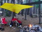
Bob pontificating about something or other as he puts up the tarp over the fire pit.

(photo by Diana: 2023-05-07 - map - explore)
Our messy but comfortable campsite. (While not denying he messiness, I think we do reasonably good job of confining the mess to a small area.
After lunch we finished setting up camp and then went for an exploratory walk. We wanted to determine if there was a reasonable route to the railbed which could facilitate walks to the site of Tom Thomson's painting Spring Lake (Rocks and Water) and to Rowan Creek. We concluded that yes we could do that but using the canoe was probably more to the point. We returned to camp after about 45 minutes, made afternoon coffee and started a fire. We put on the soup at about 4:30.

(photo by Bob: 2023-05-07 - map - explore)
A small pine-covered rocky island in the bay between our campsite and the Grand Lake Tombolo (see Notes). There are feature of this formation and its almost connection to the shore that strikes us that it might be an incipient tombolo but actual geologists might have other thoughts.
A pair of loons swam by quite close to shore and an unidentified helicopter flew over at quite high altitude. That was the first sign of human life since leaving Achray. One thing we noted is how quiet it was — essentially no birds and no wind noise. The lack of birds was puzzling.
We were visited by a mink when we were having our soup. It was a very short visit. He exited the lake at the landing spot and ran off into the bush towards the next campsite.
For supper we had Alpinaire Spicy Grilled Chicken Curry. We both thought it was quite fine but certainly spicy. It warrants having again.
By 7:30, the dishes were done, the food was up, and we were sitting enjoying the fire and the stillness. The lake is approaching mirror smooth. The sky has a high overcast but with some defined clouds at lower levels (there will be no star gazing tonight).
It was a quiet night — very bright moon — but Diana was only marginally warm. This was concerning since we had run into this same issue last fall (Diana has a quality sleeping bag rated to -9C). But by adding some extra insulation, she was OK for the rest of the trip.

(photo by Bob: 2023-05-07 - map - explore)
The sun briefly broke through the clouds at sunset.

(photo by Bob: 2023-05-07 - map - explore)
Diana relaxing by the fire.

(photo by Bob: 2023-05-07 - map - explore)
It was not until few weeks later that a fire ban was imposed on most of the Province. At the time, the conditions were dry but not dangerously so.

(photo by Bob: 2023-05-07 - map - explore)
Blue hour.
Monday May 08
We were out of the tent at about 5:20. The sky was largely clear but probably with a high thin overcast. While there was a pink glow at the horizon toward Achray, it was a non-photogenic sunrise. The temperature was about 4C.
It was a nice day but with a milky sky and a cool breeze. After breakfast we paddled down to the big rock, that is, the location of Tom Thomson's painting Spring Lake (Rocks and Water). While passing by the tombolo we saw, to our surprise, there was somebody there. However, we never saw any other sign of their presence for the rest of the trip. We landed the canoe a little west of the big rock and then walked to it along the railbed. In marrying up the scene with Tom Thomson's painting we didn't get any new insights. Bob's idea that perhaps Thomson was situated a little farther back in the bush but at the same elevation as the top of the rock, didn't pan out. We remain convinced that that is the correct location but you can't match the painting because of current vegetation growth. It also seems that different aspect of the painting were observed from slightly different locations. But the background is definitive.
After multiple photos we returned to the campsite for snacks and lunch.

(photo by Bob: 2023-05-08 - map - explore)
A tunnel of birch along the old railbed.

(photo by Diana: 2023-05-08 - map - explore)
Close to where we believe Tom Thomson painted "Spring Lake (Rocks and Water)".

(photo by Bob: 2023-05-08 - map - explore)
Lichen

(photo by Diana: 2023-05-08 - map - explore)
The background of this photo matches the background in Tom Thomson's painting "Spring Lake (Rocks and Water)".

(photo by Bob: 2023-05-08 - map - explore)
The photographer.

(photo by Diana: 2023-05-08 - map - explore)
The other photographer.

(photo by Diana: 2023-05-08 - map - explore)
Bob strolling along the railbed.

(photo by Bob: 2023-05-08 - map - explore)
Our campsite (farther shore) as viewed from the vicinity of the big rock (i.e. the site of the Tom Thomson painting "Spring Lake (Rocks and Water)"). The straight line distance is about 1.5 km.
Wind gusts were an issue all afternoon, necessitating tightening up guy lines and repegging. We eventually deployed Diana's footprint as a wind break. As it did last fall, it worked remarkably well. (We each carry a one person tent footprint as small utility tarps; Bob's was already deployed over the fire pit.)
After lunch, Diana had a snooze while Bob went exploring along the lake shore to the west. His plan was to walk along the shore until he reached Rowan Creek and then follow the creek upstream to the railbed. He reached the mouth of Rowan Creek without undue difficulty, but following upstream was not reasonably feasible — the bank was very steep with lots of broken rock and obstructed with multiple blowdowns.
There were also a lot of blowdowns in the bush between the adjacent campsite and Rowan Creek. What was noteworthy were the many very large decaying cedar stumps. this must have been a remarkable piece of bush at one time.
Bob returned to camp for snacks and afternoon coffee.
Monday's supper choice was Alpinaire Sweet and Sour Grilled Chicken. We both thought it was OK with Diana being a little more positive than Bob.
Bob's sciatica was being somewhat problematic — it was OK if he didn't do anything.
By 7:15, all chores had been completed and we were enjoying our Bushmills and the light of the setting sun (our view was to the south southeast). The wind seemed to have diminished. The sky remained milky. We were into the tent for the night by about 9:00.

(photo by Diana: 2023-05-08 - map - explore)
A glacial erratic.

(photo by Diana: 2023-05-08 - map - explore)
At the adjacent campsite.

(photo by Bob: 2023-05-08 - map - explore)
Rowan Creek on foot.
Tuesday May 09
Monday night was a cool night. The temperature was about 0C upon arising in the morning. The night had been quiet, not windy, with lots of stars early in the night. Later the moon had risen and was remarkable for its red colour. We were out of the tent and making coffee at about 6:00. It was another non-photogenic sunrise. There was high cloud with some blue showing but no strong direct sunlight. A minimal breeze was blowing down the lake.
After breakfast we paddled up the lake to explore Rowan Creek. By then the breeze had increased but it wasn't yet an issue. First we went into the mouth of the creek where Bob had reached by land the previous day. Then we paddled up the lake towards the Rowan Lake portage. Several hundred meters short of the portage, we found a suitable landing spot just at the east end of the section of railbed that forms the north shore of the lake. This particular spot allowed quite easy access to the railbed. As we were landing, we encountered a pair of hikers, male and female, hiking towards Achray. We acknowledged each others presence but there was no meaningful interaction. We then walked east along the railbed to the Rowan Creek wetlands. After some photography we returned to the canoe. For no particular reason we continued up the lake to the Rowan Lake portage. The access to the railbed here was less convenient than our other landing spot. We then paddled back to camp for lunch and a snooze. (The observant reader will note that we have lots of snacks and snoozes).

(photo by Bob: 2023-05-09 - map - explore)
Our campsite

(photo by Diana: 2023-05-09 - map - explore)
Rowan Creek from the canoe.

(photo by Diana: 2023-05-09 - map - explore)
From Rowan Creek looking back toward Grand Lake.

(photo by Diana: 2023-05-09 - map - explore)
Birches along the shore of Grand Lake.

(photo by Bob: 2023-05-09 - map - explore)
Service Berry just coming into bloom.

(photo by Bob: 2023-05-09 - map - explore)
Emergent leaves.

(photo by Diana: 2023-05-09 - map - explore)
The railbed adjacent to the Rowan Creek wetlands

(photo by Bob: 2023-05-09 - map - explore)
Stumps.

(photo by Diana: 2023-05-09 - map - explore)
The Rowan Creek wetlands.

(photo by Bob: 2023-05-09 - map - explore)
Looking back down Grand Lake.
The afternoon was sunny with a largely clear blue sky; it was not particularly milky. The breeze had increased. It kept increasing and then a whirlwind/water devil came around the point at the next campsite. It first appeared as a cloud of mist followed by the whirlwind. That is, the mist was spray on the downwind side of the whirlwind, The whirlwind was characterized by a very rough, turbulent water surface and rotating spray rising 10-15' in the air. It was quite violent and very localized. We have no doubt it would have upended any canoe it caught on open water. The whole thing appeared and then dissipated before we could get our cameras. Things then returned to normal with just a gentle breeze.
This is the second time we have encountered a whirlwind/water devil in Algonquin Park. The first time was in 1976 on Lake Travers. (It is briefly mentioned in our Bushlog Trip Log - Wendigo Lake to McManus Lake via The Petawawa River). If one were to catch you in a canoe in open water it would be bad news. (At Lake Travers we were close to shore and that one was less violent than this one on Grand Lake).
The third edition of S. Bernard Shaw's book, Canoe Lake, Algonquin Park [1], includes an addendum that advances the theory that Tom Thomson's death might be attributable to a whirlwind/water devil. This theory has not gained any traction. In what we believe is the most authoritative discussion of Thomson's death [2], Klages argues against weather as a contributing factor on the the basis of the lack of supporting observations and records — nothing out of the ordinary was in the weather records or mentioned in contemporary accounts. We would argue that because of the very transitory nature of whirlwinds/water devils, one could easily have passed unseen and thus the lack of recorded supporting observations is not conclusive. We need to be clear, however, that we are not arguing the this is what we think happened, but only that we accept this is something that conceivably could have happened. The tied-in paddles argue against this having happened out in the lake.
Early in the afternoon a red and white helicopter with yellow bottom had flown over heading west. Later in the afternoon a yellow MNR helicopter arrived out of Carcajou Bay, circled a couple of times, and landed at the west beach at Achray. After perhaps 15 minutes, it left as it came.
Supper was Alpinaire Creamy Beef and Noodles with Mushrooms. It was better than expected and we can have it again. By 7:30 everything was dead quiet and we were having our Bushmills.

(photo by Bob: 2023-05-09 - map - explore)
Diana back at the campsite.

(photo by Bob: 2023-05-09 - map - explore)
Spring colours across the lake.
Wednesday May 10
Tuesday night was another quiet night. The morning felt warmer but the temperature was at most 1 or 2C. The sky was milky with a high overcast and no defined clouds. The sun rose as a red sphere. It felt damp but the POP was 0% according to the InReach weather forecast. The sky continued to be milky with the air somewhat hazy all day; perhaps it was an effect of the forest fires out west.
After breakfast we paddled over to the campsite opposite Achray. It is a nicely situated site and it is well used. But there are no really good tent spots — we're fussy; we like level spots. It would not be our first choice of sites but it would be useable.
We then paddled over to the mouth of Carcajou Bay. There were lots of dead trees. We attribute this die-off to the drought of 2012 (see our bushlog Drought). There was nothing particularly photogenic about that location in the day's lighting conditions.
We entered the bay and examined the pictographs. They seemed more prominent than usual and we think we saw a few other markings beyond the "backwards E". We continued a way into the bay looking for photo opportunities but nothing really stood out. There was nothing wrong with the scenery, the issue was the lackluster light. We then paddled along the east shore to the egress of the Barron River, while looking for the location of Tom Thomson's painting Yellow Sunset. We're reasonably sure it is from along that shore.
Our plan was to also check out the two campsites south of the egress of the Barron but the lake was becoming quite lively and the landings poor so we decided to save that for another day.

(photo by Diana: 2023-05-10 - map - explore)
At our campsite.

(photo by Diana: 2023-05-10 - map - explore)
A little messy but the debris is largely confined to a small area.

(photo by Diana: 2023-05-10 - map - explore)
At the mouth of Carcajou Bay.

(photo by Bob: 2023-05-10 - map - explore)
Approaching the pictograph site. (The pictograph is discernible in this photo if you know exactly where to look).

(photo by Diana: 2023-05-10 - map - explore)
The pictograph

(photo by Bob: 2023-05-10 - map - explore)
Cracked bedrock.

(photo by Bob: 2023-05-10 - map - explore)
Lichen lawn in Carcajou Bay
After passing the by two campsites we landed at the indigenous campsite at the egress of the Baron to have a snack out of the wind. There were whitecaps blowing down the lake. Getting back to our campsite was going to be a challenge. We entered the Barron River and paddled a few hundred metres downstream and then pulled the canoe over the sand isthmus back to Grand Lake. This saved us a little paddling along the lee shore. Whether it was worth the detour is a separate question, but it seemed like a good idea at the time and it wasn't difficult.
After dragging across the sand spit and we launched into the lake. We didn't take any photos at the launch point — we're still trying to nail down the location of the Tom Thomson painting The West Wind — nor did we detour to the Jack Pine site (The site of Tom Thomson's painting The Jack Pine) or the mouth of Johnston Creek (another possible West Wind site). Instead we paddled straight towards the west beach/cottage beach. It was a hard slog into the wind. We carried across the isthmus at the tombolo and then over to our campsite. We were both quite tired. Bob applied Voltaren (a topical anti-inflammatory) to his elbow. (Voltaren seemed like a good idea to take on this trip, but in fact, it is too messy for bush use). We had coffee, snacks and a nap, followed by soup and supper. Supper was Alpinaire Spicy Mexican Grilled Chicken Bowl with Rice and Beans. It was quite spicy but OK.

(photo by Diana: 2023-05-10 - map - explore)
Bob contemplating his afternoon coffee.

(photo by Bob: 2023-05-10 - map - explore)
Trying (unsuccessfully) to photograph the belt of Venus.
Thursday May 11
We woke up Thursday morning to the sound of rain and consequently we procrastinated in getting out of the tent. But in fact the rain was very light and it was the most photogenic sunrise all trip. (It rained much harder a little later.) The rain stopped and after breakfast we packed up without incident. A canoe went by heading west — the first we had seen all week. The weather cleared and it was a gorgeous day — dead calm. At Achray, there were three other vehicles in the canoe parking area, two in the backpacking lot. The campground was still not operating (it was opening the next day, Friday). We stopped for snacks at the “triangle” and were home by mid afternoon. We were both very tired and stiff.

(photo by Bob: 2023-05-11 - map - explore)
Dawn

(photo by Bob: 2023-05-11 - map - explore)
Post dawn shower.

(photo by Bob: 2023-05-11 - map - explore)
Clearing

(photo by Diana: 2023-05-11 - map - explore)
What's she doing with that camera?

(photo by Diana: 2023-05-11 - map - explore)
Packing up.

(photo by Diana: 2023-05-11 - explore)
Tying the canoe on.
It was a good trip. We had the lake to ourselves. The weather was reasonable. We had planned activities every day and we accomplished them. Our provisioning and equipment worked well. And the trip was well within our physical capabilities even though it did leave us both somewhat stiff. Ten out of ten; would do it again.
Notes
A tombolo is deposition landform in which an island is connected to the mainland by a sandy isthmus. The term tombolo refers to the isthmus whereas the island is a tied island. (We sloppily use the term tombolo to refer to the island / isthmus combination). The Grand Lake Tombolo is listed in the Algonquin Provincial Park Management Plan as a Class II Special Management Area (SMA)
. It is an earth science feature of local significance. While the names of special management areas are included in the Management Plan, their locations and other details are not publicly identified. Operational guidelines for the protection of Class I SMAs are included in the management plan, but none for Class II SMAs. The tied island of the Grand Lake Tombolo is the site of a cottage lease.
Sources
[1] S. Bernard Shaw (2003), Canoe Lake, Algonquin Park — Tom Thomson and Other Mysteries, 3rd edition, General Store Publishing House, Burnstown.
[2] Gregory Klages (2016), The Many Deaths of Tom Thomson — Separating Fact From Fiction, Dundurn Press, Toronto.