(photo by Bob: 2006-04-27 - explore )
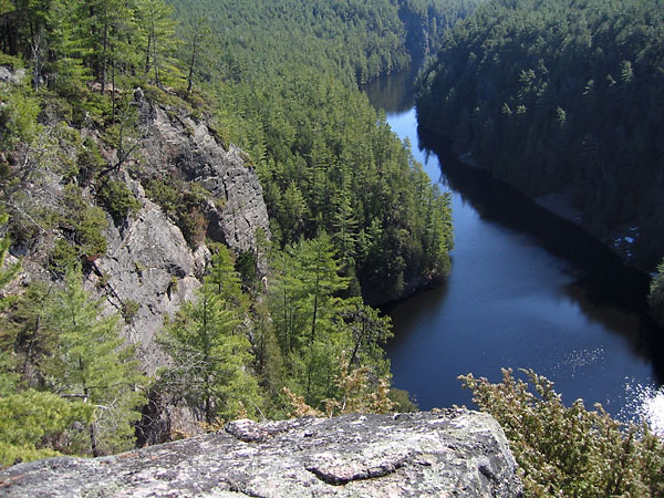
The Barron Canyon Nature Reserve (N57) is a provincially significant upland forest and outcrop complex and is part of the Ottawa Bonnechere Graben .
The intent of this page is to provide an index to the Nature Reserve Zones and Special Management Areas in Algonquin Park and to link to further information on this site, if available. The focus will be on the eastern and northern side of the Park.
The key documents with respect to these sites are the Algonquin Provincial Park Management Plan and Algonquin Park Management Plan Amendment . Another useful guide is A Nature Guide to Ontario by the Federation of Ontario Naturalists (now Ontario Nature). However, this latter reference is most useful for sites outside of the Park.
(For an interactive map of all of the natural zones of Algonquin Park see Interactive Map of Algonquin Park .)
Nature Reserve Zones in Algonquin Park From the Algonquin Park Management Plan:
Nature Reserve Zones include any significant earth and life science features that require management distinct from that in adjacent zones.
Implicit in this statement is that these features require enhanced protection.
Natural Zones Anglin-Dickson White Pine (N35) Provincially significant upland forest. Barron River Canyon (N57) Provincially significant upland forest and outcrop complex. Part of the Ottawa Bonnechere Graben. Berm Lake Bog (N71) Regionally significant peatland. Big Crow Lake Esker Complex (N87) Regionally significant esker complex. Big Crow White Pine (N33) Provincially significant upland forest. Bog Lemming Site (N56) Locally significant mammal population site. Bonanza Bay Marsh (N07) Provincially significant marsh and deciduous swamp forest. Bonnechere Jack Pine (N43) Regionally significant upland forest. Bonnechere Sedge Meadow (N14) Regionally significant wetland complex. Booth Lake Bog (N13) Regionally significant wetland complex. Brent Crater (N62) Meteor crater. A provincially significant upland and lowland complex. Brent Limestone Cliff (N63) Regionally significant bedrock complex. Bruton and Clyde Red Spruce (N46) Provincially significant upland forest complex. Cameron Creek Bog (N01) Provincially significant wetland complex. Carcajou Bay - Spectacle Lakes (N50) Provincially significant upland forest and wetland complex. Carcajou Jack Pine (N44) Provincially significant upland forest. Carcajou Sedge Meadow (N16) Regionally significant wetland complex. Carl Wilson Lake Hardwoods (N20) Provincially significant upland forest and outcrop complex. Carl Wilson White Pine and Kame Moraine (N36) Regionally significant upland forest complex. Regionally significant kame moraine. Cauchon Lake Burn (N65) Regionally significant upland & forest complex. Cauliflower Lake Red Spruce (N45) Locally significant upland and lowland forest complex. Cayuga Lake Hemlock (N31) Provincially significant upland forest complex. Cedar-Nipissing Marsh (N09) Provincially significant marsh complex. Chainfern Bog (N77) Regionally significant wetland. Charles Lake White Pine (N72) Regionally significant forest stand. Chela Lake (N93) Clyde Marsh (N15) Regionally significant wetland and cliff complex. Coldspring Watershed (N69) Provincially significant watershed unit. Regionally significant moraine & eskers.. Costello Creek Bog (N10) Regionally significant wetland & granitic outcrop complex. Crow Lake Blowdown (N67) Regionally significant natural succession process. Crow Lake Cliff (N59) Regionally significant cliff complex. Crow River Jack Pine (N42) Locally significant upland forest. Crow River Young White Pine (N37) Locally significant upland forest. David Creek Bog (N02) Provincially significant peatland complex. Devils Chute (N51) Regionally significant upland & shoreline complex. Dickson Lake (N30) Provincially significant upland forest. Dickson Lake Hardwoods (N21) Provincially significant upland forest & wetland complex. Dividing Lake - Livingstone Township White Pine (N32) Provincially significant upland forest & old growth. Eustache Lake (N60) Provincially significant aquatic & upland complex. Fitzgerald Township Moraine (N91) Regionally significant large moraine. Found Lake (N52) Regionally significant floristic site. Gibson Lake (N97) Grand Lake Ice Marginal Channels (N90) Regionally significant ice marginal channels. Grand Lake Marsh (N08) Regionally significant wetland complex. Grassy Bay Mog (N11) Locally significant wetland and kame complex. Greenleaf Creek Watershed (N70) Provincially significant watershed . Hailstorm Creek and Kame Complex (N12) Provincially significant wetland complex. Regionally significant kame complex.. High Falls (N54) Locally significant upland complex. Hilliard Lake Fern Stand (N61) Regionally significant floristic site. Hogan Lake Mog (N06) Provincially significant wetland complex. Locally significant morainic ridges. Hurdman Creek Black Ash (N29) Regionally significant lowland forest complex. Keegos Lake Bog (N04) Provincially significant peatland complex. Kingscote Lake Hardwoods (N18) Regionally significant hardwood forest. Lake Lavieille Hemlock (N73) Provincially significant upland forest. Lake Travers DeGeer Moraines (N84) Provincially significant DeGeer-type moraines. Lake Travers Dune Complex (N74) Provincially significant upland forest and wetland. Provincially significant inland dune field.. Lake Travers Sand Dunes (N85) Lavieille Red Pine (N40) Regionally significant upland forest. Loontail Lake Gravelly Moraine (N80) Regionally significant gravelly moraine. Manitou Lake Blowdown (N68) Locally significant upland forest. McKaskill Lake Kame Complex (N89) Regionally significant kame esker complex, ice contact face. McManus Lake Basswood (N27) Regionally significant upland forest & shore vegetation. Merchant Lake Blowdown (N66) Locally significant upland forest. Minnehaha Lake Kame Moraine (N78) Regionally significant glaciofluvial landforms (eskers, kettles, and kame moraines). Minto Lake Hardwoods (N22) Regionally significant upland forest. Mud Bay Aquatics (N75) Regionally significant aquatic floristic complex. Nadine Lake Hardwoods (N19) Provincially significant upland hardwood forest and shoreline complex. Nipissing River Sedge Meadow (N17) Regionally significant wetland complex. Nipissing Valley White Pine (N38) Locally significant upland forest. North River Lake (N92) Oak Lake Red Spruce (N47) Provincially significant upland forest and wetland complex. Old Pine Reserve (N34) Regionally significant upland forest. Opeongo Red Pine (N41) Locally significant upland forest. Oxtongue River Silver Maple (N25) Locally significant lowland forest. Parkline Lake (N94) Petawawa Rapids (N55) Provincially significant upland forest, lowland & shoreline complex. Part of the Ottawa Bonnechere Graben.. Radiant Lake Kame Terrace (N86) Provincially significant ice contact kame terraces. Rana Lake Red Oak (N26) Provincially significant upland forest. Robitaille Creek Terraces (N82) Regionally significant erosional terraces. Rosebary Lake (N48) Provincially significant Beach & upland forest complex. Round-bush Lake (N95) Skunkitten Lake Bog (N03) Locally significant peatland complex. Spoor Lake (N76) Provincially significant upland and wetland complex. Tarn Lake (N49) Provincially significant upland forest, open outcrop & wetland complex. Thomas Lake Kettle Bog (N05) Locally significant peatland complex. Tim River Burn (N64) Provincially significant upland meadow complex. Upper Pine River (N53) Provincially significant wetland & intolerant upland forest complex. Wenda Lake Hardwoods (N23) Provincially significant upland forest. White Partridge Cliff (N58) Regionally significant floristic site. White Partridge Lake Erosional Terraces (N88) Provincially significant erosional terraces. Whitson Lake (N24) Provincially significant upland, lowland forest & wetland complex. Wilkes Lake Basswood (N28) Locally significant upland forest. Wilkes Lake Ice Marginal Delta (N81) Regionally significant kame complex. Wilkins Lake (N96) Special Management Areas in Algonquin Park From the Algonquin Park Management Plan:
Provincially and regionally significant earth science sites have been designated Nature Reserve Zones to provide then with the highest form of protection. Larger assemblages, some regionally significant features, and small features of local significance are protected in Special Management Areas.
Achray Beaches/Deposits Locally significant beach ridges, off-shore deposits. Biggar Twp Gravelly Moraine Regionally significant gravelly moraine. Bonnechere Valley Outwash System Regionally significant outwash system. Booth Lake Delta Regionally significant outwash delta. Brent Fluted Till Plain Regionally significant fluted till, drumlins. Bronson-Straton Outwash Plain Regionally significant outwash plain, meltwater channels. Clemow Lake Drumlin Group Regionally significant drumlins. Coldspring Lake/Carl Wilson Complex Regionally significant Kame esker complex. Forbes Creek Meltwater Channel Locally significant meltwater channel. Grand Lake Boulder Pavement Regionally significant boulder lag. Grand Lake Tombolo Locally significant tombolo. Grassy Bay Kame Complex Locally significant Kame-esker complex. (Protected within the Grassy Bay Mog nature reserve and the Burnt Island Wilderness Zone.) Grosbeak Creek Outwash/Kame Terraces Regionally significant ice contact material, eskers, kettle. Hogan Lake Esker Locally significant esker kame. Lake Travers Outwash Plain Regionally significant glaciofluvial landforms. Lake Of Two Rivers Outwash Plain Locally significant outwash plain. Modern Fluvial Deltas (3) Locally significant modern fluvial deposits. North Rouge Creek Drumlins Regionally significant drumlins, drumlinoidal features. Notsolong Lake Esker Locally significant large esker. Oxtounge River Outwash Plain Locally significant outwash plain. Petawawa Terraces Regionally significant erosional terraces. Proulx Lake Outwash Regionally significant outwash plain, Kame complex. Radiant Lake Kame Terraces Regionally significant Kame esker complex. Sunfish Lake Moraininc Ridge Locally significant small moraine. White Partridge Lake Spillway Locally significant outwash plain, meltwater channels.
Sources
Ministry of Natural Resources (1998), Algonquin Provincial Park Management Plan
Ministry of Natural Resources (2013), Algonquin Park Management Plan Amendment
Winifred (Cairns) Wake, John Cartwright, Anne Champagne, Kathy Parker, and Martin Parker, eds. (1997), A Nature Guide to Ontario , University of Toronto Press.